EDIT: 29/3Z Snow is moving in from the southwest this evening. Not expecting much accumulation from this weak disturbance, maybe 1" to 2" tops for the local area. We have chance of snow during the day Wednesday as well, little to any additional accumulation. Another chance of snow enters the forecast over the weekend with a chance of light accumulations. The bigger story comes the weekend after next where a larger storm system is beginning to show up on the models! Just in time for the SKEW-T / Hodograph class in Cameron, YEAH!
If you are a believer in long wave patterns recurring during a set time frame (my thoughts are 58 to 62 days this year) then it is no suprise we have a chance of snow in the Tuesday into Wednesday time frame. For more info on long wave patterns visit http://www.lrcweather.com/.
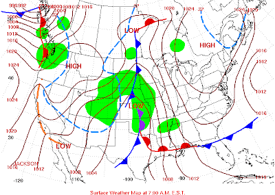
This is not a major storm but enough to produce accumulating snow in the 2" to 4" range for the local area based on current model data. Here is a look back at the October 29, 2009 storm that moved through our area:
I expect this storm to track to the south and east of the local area due to the position of the southern jet and cold air in place. There is no doubt the precipitation will be all snow with this system. It moved through fairly quick in October and dropped between 0.10 and 0.20 of precipiation. Will the storm track further south and east? Will the storm slow down this time and procude more precipiation in the local area? Watch the blog as we track the system toward mid-week! ~ CS
We are also currently working on our new storm chasing media website, http://www.mesoextrememedia.com/. It is in the development stages and we hope to have it up and fully operational by February 2010. Check back often as we develop the site!


No comments:
Post a Comment