A potent late winter storm affected the area beginning Saturday evening and continued through the day on Sunday. A convective band of snow lined up from MCI to STJ and to the east northeast from there. This was a very classic track and set up for the local area with a deformation zone/TROWAL forming on the north and northwest side of the low pressure center. This produced snowfall rates at 1" to 2" per hour during the mid to late afternoon hours. Snowfall accumulations met the forecasted totals of 5" to 10" with local reoprts of 12" of snow.
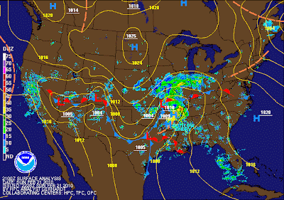
Currently, the area of low pressure is located over southeast Missouri and continues to lift off to the ENE. This will allow the snow to taper off to flurries, but usher in strong north winds in the 20 to 25 mph range which will cause blowing and drifting of snow. Here is a look at the surface map valid as of 12 a.m. CST February 22, 2010:
Looking at current radar trends indicate there is a band of light snow spinning around the backside of the storm from near Maryville, MO to Topeka, KS. This band of snow should clear the local area by 9 p.m. CST. I am expecting only minor additional accumulations. Here is a look at the current surface map / radar returns:
Roads in northern MO are snow covered and slick. Travel is highly discouraged at this time until road crews can get the roads cleared of snow and treated. This will be complicated by the pesky north wind. County roads are nearly impassable across the area. Exercise extreme caution if you must venture our this evening. Have an emergency travel kit, blankets, snow shovel and cell phone with you. ~ CS


No comments:
Post a Comment